If you look at the Wikipedia article on U.S. Route 6, you’ll see that they follow the course of the road from West to East. The road signs along the route are also easier to follow traveling West to East. There is a significant sign marking the beginning of modern Route 6 in Bishop, CA, but none marking the beginning in Provincetown, MA. I don’t really understand why, however. We traveled the Route from East to West, and I have no doubt that this is the proper way it should be done. First, traveling in this manner, the scenery becomes more and more dramatic as you head out West. Second, this is the way, historically, people traveled on the road in an attempt to strike it rich in the many (now abandoned) mining towns of the West. And last, this is the direction in which Mateo traveled on his way into serving Active Duty in the military.
That all being said, the next time we do this, we will travel from West to East. Yes, folks, I said next time. I do believe that we plan on doing this cross country road trip again. I imagine not for another 10 years, but eventually.
We figure that we’ll attempt the Route in a large van or small RV to make life a little more comfortable. We’ll also probably do it with an animal or kid(s) in the car. We are hoping that by doing it in the opposite direction we’ll have more energy for exploring the intriguing western part of the Route.
While the scenery on the East Coast can be lush and green, with waterfalls, wooden bridges, and so on, we really prefer the Western part of the Route. I absolutely HATE dust, but I enjoy the painted cliff sides of sandstone, the endless miles of solitude. We like exploring and taking pictures of our abandoned and forgotten past, old mining towns. There are some caves and National Forest lands that we would like to take more time exploring. A white water rafting expedition in Colorado would be fabulous, as would taking the time to fossil hunt or ride an ATV in the sand dunes of Utah.
We’d also like to spend more time taking side dirt roads with a GPS and decent directions to explore the lunar crater (which we couldn’t find this trip) and perhaps more hot springs.
Personally, I would also like to have the money and the stomach to stop in at little owner-run restaurants and to try local bison burgers, chili, steaks, pies, and curds. When we stopped at a small coffeshop on the East Coast, we had a great time talking with the owner and sampling free coffee that he roasts himself with pride.
We had experiences like these speckled throughout our trip, but we’d really like the time to enjoy more of them.
Who’d like to join us? Start saving your pennies!
Sunday, May 16, 2010
Igloo in Nevada (May 11)
At around 6am the cat woke me up. She was restless. I didn't really focus my eyes. I probably didn't even open them. I just moved my hand around inside the sleeping bag for the cat to chase, so she'd be entertained enough to quit meowing. But, the usual trick didn't work. She was insistent on clawing at the ceiling of the car and scraping at the windows. This was the first time she had done such a thing, so my curiosity was peeked. I opened/focused my eyes.
 SNOW! Snow covered the entire car. I couldn't see out. Perhaps this is why the cat was panicking a little, she figured we were being buried alive. I found out soon enough that a whole four inches or so of snow covered us in the night. We were literally in an igloo, which is probably why for the first time on our trip I didn't wake up freezing. The thick layer of snow covering us had trapped in some warmth overnight.
My astonishment was quickly replaced by concern. We had parked the car purposefully in a concealed area, two miles from the main road. The main road which is actually quite a lonely road, 100 miles to the next services. The main road which had been closed for a weekend due to snowfall just this month. And we had no cell phone reception. Basically, we were in the middle of nowhere, unprepared for the weather, and dealing with the possibility that we might be stuck.
 Mateo grabbed his Army jacket and scraped off the snow with a shoe of mine. We didn't bring a snow brush. I thought about it. I packed one away for the trip, but somehow it got tossed into the jumble of us moving all our household goods. So he tried his best with a shoe.
I turned on the defrost and it turned a nickel-size chip in our windshield into a full two foot crack!
I packed away our sleeping bags behind us in a huge mess, because I wasn't getting out of the car in the snow. Mateo returned behind the wheel a good 15 minutes later and we set off precariously down the dirt, now snow-covered road.
Yup, we missed the lunar crater. There was no way we were traveling further down the unmaintained roads with snow coming down like it was. Our plan was to get to the major road, assess the conditions, and possibly wait a few days for Route 6 to be cleared. Thankfully the Route wasn't in too poor of condition. Mateo just took the roads slowly (25mph slow)
And, an hour down the road, coming the opposite direction we were met by someone clearing the roads. I sighed a bit of relief at the sight of the snow plow... we wouldn't be stuck on the road!
We would have been in decent condition if we had been stuck, however. We had sleeping gear, food, water, etc. We had no cell phone reception what so ever, but I think we could have managed a few nights in that spot if we had to.
 Once we cleared past the snowy area and hit the sunny, desert heat we pulled over and took a short, badly needed nap to recover from the early morning adventure.
So, apparently kitty doesn't like snow. Or maybe it was the not being able to see out the window. Anyhow, I like to think she's destined to be a Hawaiian kitty.
 SNOW! Snow covered the entire car. I couldn't see out. Perhaps this is why the cat was panicking a little, she figured we were being buried alive. I found out soon enough that a whole four inches or so of snow covered us in the night. We were literally in an igloo, which is probably why for the first time on our trip I didn't wake up freezing. The thick layer of snow covering us had trapped in some warmth overnight.
My astonishment was quickly replaced by concern. We had parked the car purposefully in a concealed area, two miles from the main road. The main road which is actually quite a lonely road, 100 miles to the next services. The main road which had been closed for a weekend due to snowfall just this month. And we had no cell phone reception. Basically, we were in the middle of nowhere, unprepared for the weather, and dealing with the possibility that we might be stuck.
 Mateo grabbed his Army jacket and scraped off the snow with a shoe of mine. We didn't bring a snow brush. I thought about it. I packed one away for the trip, but somehow it got tossed into the jumble of us moving all our household goods. So he tried his best with a shoe.
I turned on the defrost and it turned a nickel-size chip in our windshield into a full two foot crack!
I packed away our sleeping bags behind us in a huge mess, because I wasn't getting out of the car in the snow. Mateo returned behind the wheel a good 15 minutes later and we set off precariously down the dirt, now snow-covered road.
Yup, we missed the lunar crater. There was no way we were traveling further down the
 unmaintained roads with snow coming down like it was. Our plan was to get to the major road, assess the conditions, and possibly wait a few days for Route 6 to be cleared. Thankfully the Route wasn't in too poor of condition. Mateo just took the roads slowly (25mph slow)
And, an hour down the road, coming the opposite direction we were met by someone clearing the roads. I sighed a bit of relief at the sight of the snow plow... we wouldn't be stuck on the road!
We would have been in decent condition if we had been stuck, however. We had sleeping gear, food, water, etc. We had no cell phone reception what so ever, but I think we could have managed a few nights in that spot if we had to.
 Once we cleared past the snowy area and hit the sunny, desert heat we pulled over and took a short, badly needed nap to recover from the early morning adventure.
So, apparently kitty doesn't like snow. Or maybe it was the not being able to see out the window. Anyhow, I like to think she's destined to be a Hawaiian kitty.
Ward Charcoal Ovens
Ward Charcoal Ovens State Historic Park is located in the Egan Mountain Range approximately 18 miles south of Ely, Nevada. This beautiful park is  mostly known for its six beehive-shaped historic charcoal ovens; however, the park offers an array of recreational opportunities. There are trails for hiking, mountain biking and ATV riding. There are abundant wildlife viewing and birding opportunities. Willow Creek, a small perennial stream, supports naturally reproducing Rainbow, Brown and Brook Trout for a unique fishing experience. In addition there are facilities for picnicking and camping. The park also has fantastic views of Wheeler Peak, located in the Great Basin National Park.
The Martin White Company commissioned the ovens to be built to supply high quality charcoal for the two silver smelters located at Ward. The six charcoal ovens were built in 1876 and were constructed by Swiss-Italian charcoal workers called "Carbonari". The ovens were made from quartz welded tuff that was quarried from the nearby hills.
The beehive shaped ovens were designed as a replacement for the open-pit system that originated in Italy. The ovens were a more efficient way to reduce all types of wood to charcoal. Vents on the bottom of the kiln allowed for fine adjustment of temperature, and the parabolic (beehive) shape reflected heat back into the center. Each oven could hold 35 cords of wood per firing, and would produce between 30 to 50 bushels of charcoal per cord of wood. All wood types were used in the ovens, including pinyon pine, juniper, aspen and even sagebrush. The entire process of loading, burning, and unloading took thirteen days.
Historians disagree about how long the Ward Charcoal Ovens were in use, however, it is most likely that they were used until the Martin White smelter shut down in 1879.
The Ward Charcoal Ovens have served diverse purposes since the end of their original use as charcoal ovens. These hills were the battlegrounds for the Charcoal Burner’s War of 1879, when Italian and Swiss immigrants fought wealthy mill owners over wages and work conditions. Ultimately the Nevada Militia was activated and five immigrants were killed in a skirmish with the deputies. They have sheltered stockmen and prospectors during foul weather, and had a reputation as the hideout for stagecoach bandits. Today, the ovens continue to represent a unique and fascinating chapter in Nevada mining history. The Nevada Division of State Parks takes pride in their continued interpretation and preservation for future generations to enjoy.
 The park is located seven miles south of Ely via U.S. 50/6/93, then 11 miles southwest on Cave Valley Road. Cave Valley Road is a graded dirt road, accessible by passenger vehicles most of the year. Daily use fee of $4 per vehicle. Interpretive trails. Bikes okay. Clean bathrooms, picnic benches, and places for bbq-ing. No running water.
 mostly known for its six beehive-shaped historic charcoal ovens; however, the park offers an array of recreational opportunities. There are trails for hiking, mountain biking and ATV riding. There are abundant wildlife viewing and birding opportunities. Willow Creek, a small perennial stream, supports naturally reproducing Rainbow, Brown and Brook Trout for a unique fishing experience. In addition there are facilities for picnicking and camping. The park also has fantastic views of Wheeler Peak, located in the Great Basin National Park.
The Martin White Company commissioned the ovens to be built to supply high quality charcoal for the two silver smelters located at Ward. The six charcoal ovens were built in 1876 and were constructed by Swiss-Italian charcoal workers called "Carbonari". The ovens were made from quartz welded tuff that was quarried from the nearby hills.
The beehive shaped ovens were designed as a replacement for the open-pit system that originated in Italy. The ovens were a more efficient way to reduce all types of wood to charcoal.
 Vents on the bottom of the kiln allowed for fine adjustment of temperature, and the parabolic (beehive) shape reflected heat back into the center. Each oven could hold 35 cords of wood per firing, and would produce between 30 to 50 bushels of charcoal per cord of wood. All wood types were used in the ovens, including pinyon pine, juniper, aspen and even sagebrush. The entire process of loading, burning, and unloading took thirteen days.
Historians disagree about how long the Ward Charcoal Ovens were in use, however, it is most likely that they were used until the Martin White smelter shut down in 1879.
The Ward Charcoal Ovens have served diverse purposes since the end of their original use as charcoal ovens. These hills were the battlegrounds for the Charcoal Burner’s War of 1879, when Italian and Swiss immigrants fought wealthy mill owners over wages and work conditions. Ultimately the Nevada Militia was activated and five immigrants were killed in a skirmish with the deputies. They have sheltered stockmen and prospectors during foul weather, and had a reputation as the hideout for stagecoach bandits. Today, the ovens continue to represent a unique and fascinating chapter in Nevada mining history. The Nevada Division of State Parks takes pride in their continued interpretation and preservation for future generations to enjoy.
 The park is located seven miles south of Ely via U.S. 50/6/93, then 11 miles southwest on Cave Valley Road. Cave Valley Road is a graded dirt road, accessible by passenger vehicles most of the year. Daily use fee of $4 per vehicle. Interpretive trails. Bikes okay. Clean bathrooms, picnic benches, and places for bbq-ing. No running water.
Saturday, May 15, 2010
Nevada
Just across the border into Nevada, we stopped at a few interesting sites. For lunch, we visited an archeological site, the excavation site of a Native  American settlement. Then we got some postcards, a free map of Nevada and some directions to local ghost towns from the Visitors' Center of the Great National Basin Park. The Visitors Center has some really nice books for sale about hot springs, the wildlife in the area, star maps, etc. I would have loved to buy some of the coffee table picture books, but we have very limited space & funds. I think that books are some great souvenirs to have. The center also had some pretty realistic fake animals and interactive displays on the land, plants, etc of the park. I swear the fake snake moved! and the taxidermied dog laying under the table made me jump. I can get quite obsessed with fake animals. I always wanted stuffed animals that looked like real animals. And, I loooooved making farm models for school projects. I get totally fascinated with the models in the visitors center. I think it would be such an awesome job to be in charge of creating these scenes.Unfortunately (later in the day) the ghost towns that
  we had been guided to turned out to be little more than a few deserted mines and fence posts. On the way to the first one we stopped because we smelled some burning. I think some kind of tumbleweed was burning on the engine. The cat ended up jumping out of the open window. But she didn't run away... she just came to see what Mateo was doing climbing under the car.
On the way to the second site we got lost. Then we decided to explore the lunar crater.

 Nevada has over a dozen volcanic areas. The best is the Lunar Crater Volcanic Field, a zone of vulcanism covering over 100 square miles at the southern end of the Pancake Range, and comprising cinder cones, outcrops of lava, elongated fissures, ash hills and, most visibly, the 430 foot deep Lunar Crater - an impressive and rather unexpected site in an otherwise isolated, windswept location. The crater is designated a National Natural Landmark, one of six in Nevada, and is situated 75 miles east of Tonopah near the center of the state. It is geologically termed a
  'maar', the name given to a shallow, broad crater formed by explosive eruptions close to ground level, usually caused by heating of subterranean water.
The circular crater is large and impressive, surrounded by dark grey-brown rocks topped by layers of black ash in which grow small but brightly colored wildflowers such as the deep red Indian paintbrush. The viewpoint on the east rim is higher than the surroundings, allowing for far reaching views in most directions, of grass-covered buttes, ridges and lava flows.
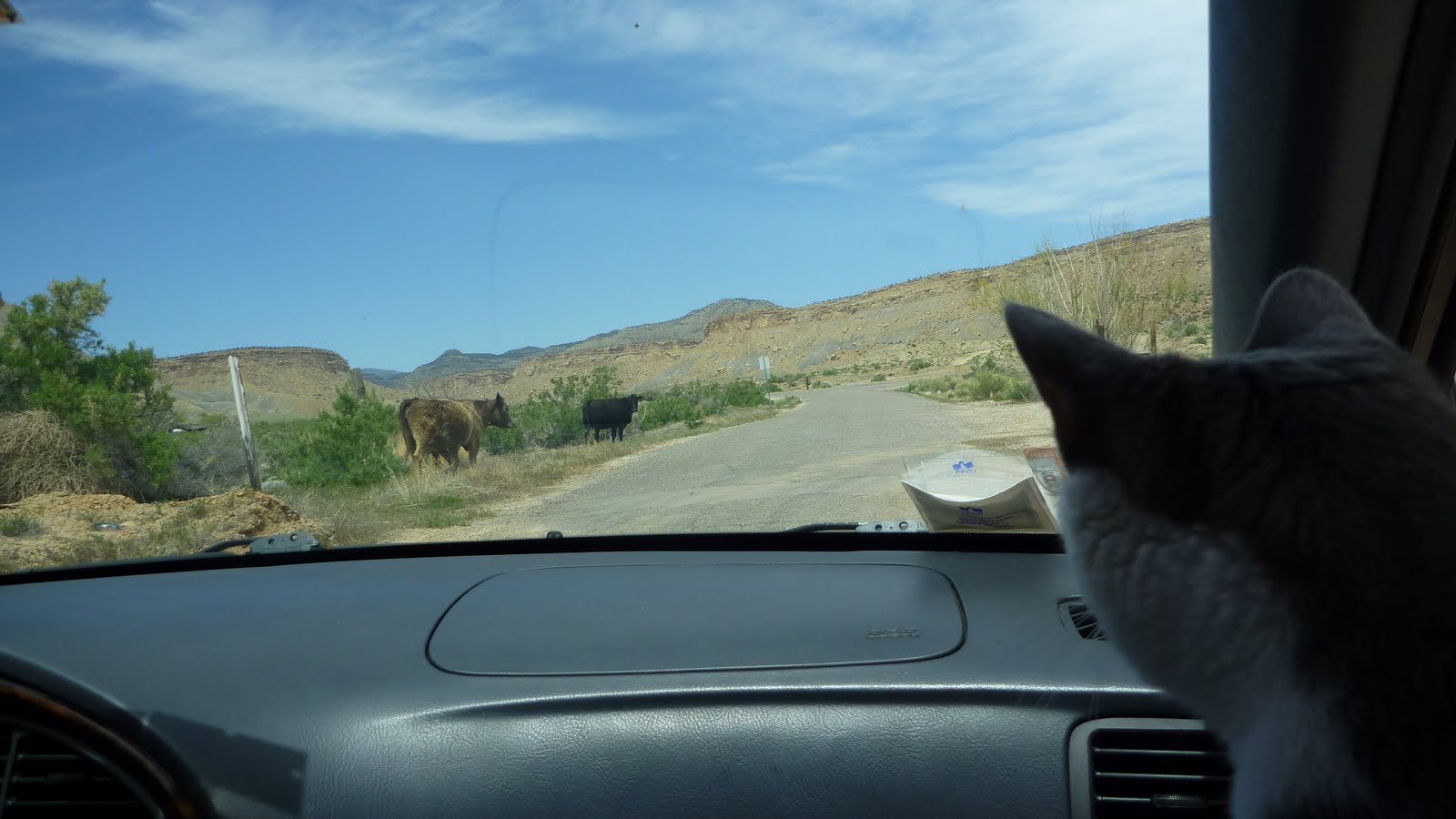
 We turned off of Route 6 onto public lands managed by the Bureau of Land Mangement at the sign for the Lunar Crater. Mateo says this is one of his favorite places on earth. He visited it the last time he did the Route 6 tour. On the way out to the site on the 8 mile dirt road, we came across two dead cows and drove alongside a large dry lake, white with minerals and salts. we pulled off the road to visit "the wall," which was an interesting formation in the side of t
 he small mountain. But, as the sun started to set and the sky darken with rain clouds, we decided to stop or search for the lunar crater. We could get much better pictures in the morning light anyway.
It was really windy and started to rain, so we parked the car near an old cow corral between two walls of rocks.
Along the way we have given away, eaten or shipped some of the boxes and extra bulk in the car; we were able to set up our sleeping arrangements in the car with only having the cooler outside in the elements. We ate a dinner of cheese, apples, chips and mango salsa, then fell asleep to the sound of rain on the car.
 American settlement. Then we got some postcards, a free map of Nevada and some directions to local ghost towns from the Visitors' Center of the Great National Basin Park. The Visitors Center has some really nice books for sale about hot springs, the wildlife in the area, star maps, etc. I would have loved to buy some of the coffee table picture books, but we have very limited space & funds. I think that books are some great souvenirs to have. The center also had some pretty realistic fake animals and interactive displays on the land, plants, etc of the park. I swear the fake snake moved! and the taxidermied dog laying under the table made me jump. I can get quite obsessed with fake animals. I always wanted stuffed animals that looked like real animals. And, I loooooved making farm models for school projects. I get totally fascinated with the models in the visitors center. I think it would be such an awesome job to be in charge of creating these scenes.Unfortunately (later in the day) the ghost towns that
  we had been guided to turned out to be little more than a few deserted mines and fence posts. On the way to the first one we stopped because we smelled some burning. I think some kind of tumbleweed was burning on the engine. The cat ended up jumping out of the open window. But she didn't run away... she just came to see what Mateo was doing climbing under the car.
On the way to the second site we got lost. Then we decided to explore the lunar crater.

 Nevada has over a dozen volcanic areas. The best is the Lunar Crater Volcanic Field, a zone of vulcanism covering over 100 square miles at the southern end of the Pancake Range, and comprising cinder cones, outcrops of lava, elongated fissures, ash hills and, most visibly, the 430 foot deep Lunar Crater - an impressive and rather unexpected site in an otherwise isolated, windswept location. The crater is designated a National Natural Landmark, one of six in Nevada, and is situated 75 miles east of Tonopah near the center of the state. It is geologically termed a
  'maar', the name given to a shallow, broad crater formed by explosive eruptions close to ground level, usually caused by heating of subterranean water.
The circular crater is large and impressive, surrounded by dark grey-brown rocks topped by layers of black ash in which grow small but brightly colored wildflowers such as the deep red Indian paintbrush. The viewpoint on the east rim is higher than the surroundings, allowing for far reaching views in most directions, of grass-covered buttes, ridges and lava flows.
 We turned off of Route 6 onto public lands managed by the Bureau of Land Mangement at the sign for the Lunar Crater. Mateo says this is one of his favorite places on earth. He visited it the last time he did the Route 6 tour. On the way out to the site on the 8 mile dirt road, we came across two dead cows and drove alongside a large dry lake, white with minerals and salts. we pulled off the road to visit "the wall," which was an interesting formation in the side of t
 he small mountain. But, as the sun started to set and the sky darken with rain clouds, we decided to stop or search for the lunar crater. We could get much better pictures in the morning light anyway.
It was really windy and started to rain, so we parked the car near an old cow corral between two walls of rocks.
Along the way we have given away, eaten or shipped some of the boxes and extra bulk in the car; we were able to set up our sleeping arrangements in the car with only having the cooler outside in the elements. We ate a dinner of cheese, apples, chips and mango salsa, then fell asleep to the sound of rain on the car.
Thursday, May 13, 2010
Unidentified Object

Can anyone identify this object? We found in the middle of nowhere in the deserted and ruined old mining town of Joy, Nevada. I thought it might be an area where people sifted, sorted, etc for gold or whatnot.
Wednesday, May 12, 2010
Crepuscular Rays

I learned today that this phenomena is called "crepuscular." Brilliant crepuscular rays streak across the sky over Colorado. Crepuscular rays are parallel columns of sunlit air separated by darker regions of clouds.
Subscribe to:
Posts (Atom)

